It seems fuel consumption rules out any of the scenarios below…
[End Update 2014-05-11 21:22 UTC]
Starting mainly with the thoughts of Duncan Steel and Warren Platts on the reconstructions of the missing MH370 flight, I thought I tried to see what possible routes the flight could have taken.
I tried to guesstimate a possible flight path taking into account the following:
- I assumed a "constant cruise" flight between waypoints, at constant true air speed (TAS) and constant flight level.
- I used the "Inmarsat ping rings" (distance only) as read out by me from the released Google Earth graphics (PDF). I made screenshots from the PDF, overlaid the screenshots in Google Earth, and moved them to get a good agreement between screenshots and map-features in Google Earth – I did this for every ping ring segment.
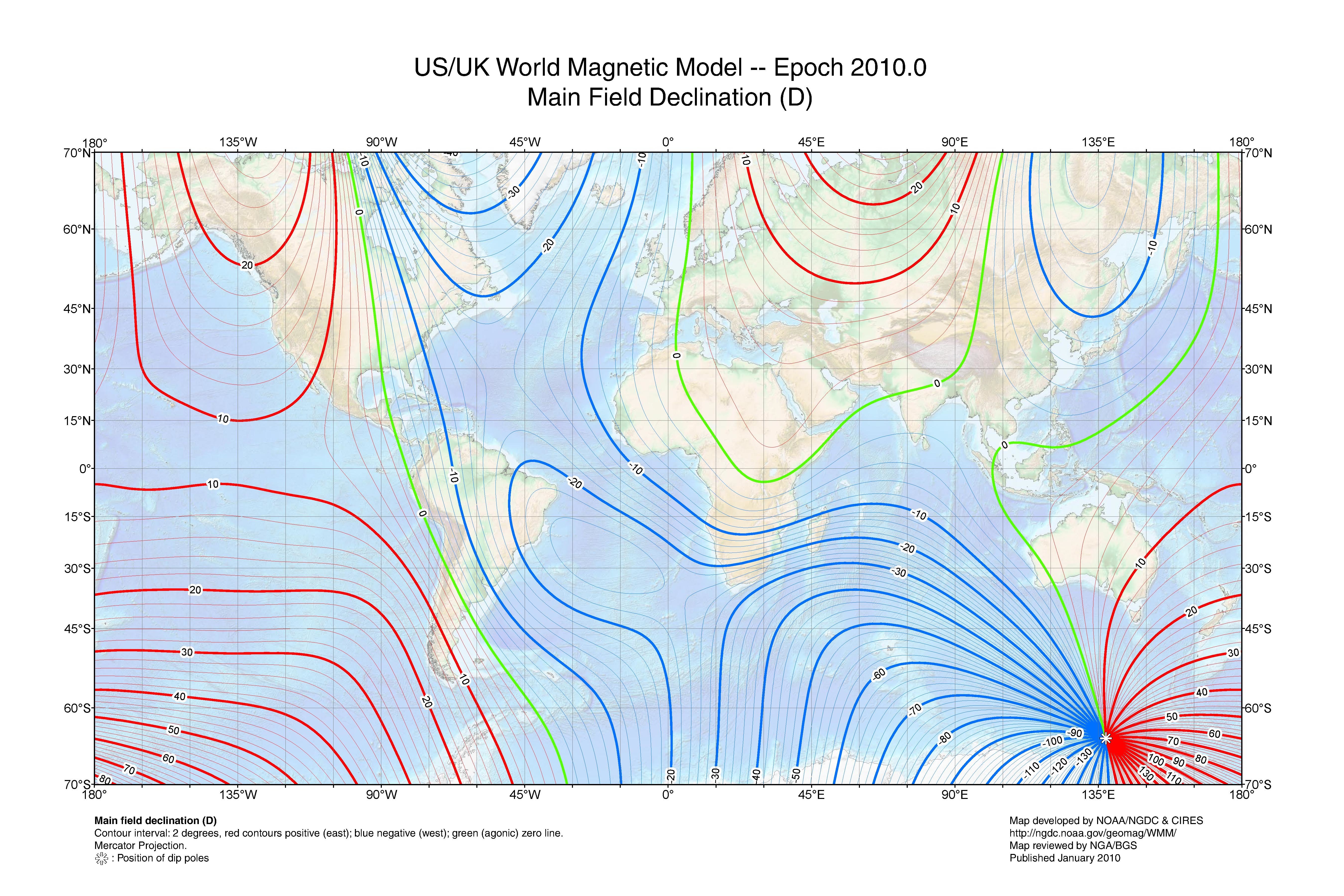
- I used then wind (but only the strong winds with about 50knots) and magnetic deviation to further refine the guesstimate of a possible waypoint based flight path. The winds before 21:41 are light (on the order of 10 knots) so I choose to ignore those – factoring in those winds could change the results, possibly invalidating my guesstimate.
Furthermore I did the following:
- I ignored the Burst Frequency Offset (BFO) diagrams. An publicly not known formula is needed to convert those BFO points into doppler shift (which then could be used to compute line of sight speed). A trustworthy reconstruction of the line of sight speed could be used (once available) to falsify any reconstruction (or possibly lend more credence to it).
- Furthermore I ignored any fuel range considerations – factoring in fuel range could possibly invalidate my guesstimate.
- I got waypoints from skyvector and other sites.
- I used Google Earth to compute distances between waypoints.
- I assumed the last known position to be the waypoint NILAM, which introduces a small error on the order of 10 to 15 nautical miles.
- Every measurement I made introduces an uncertainty of at least a few nautical miles – the reconstruction is meant as an guesstimate mainly to rule out paths that clearly do not fit the "waypoint cruise" scenario.
- Once I had a halfway good accordance between hypothetical track and the ping rings, I factored in wind (and in one case magnetic deviation)
I tried the following scenarios
- Scenario SPOLE: I first tried a "simple" scenario with a flight consistent to the southpole (SPOLE) via ISBIX – the SPOLE scenario is the simplest, but is not in accordance with the Inmarsat ping rings and a constant cruise.
- Scenario RUNUT/189: After the simple SPOLE scenario failed, I used a route via MUTMI and RUNUT, as presented by Warren Platts. After RUNUT, I assumed a heading of 189. While in somewhat good agreement until 21:41, the RUNUT/189 scenario fails after that, mainly due to strong crosswinds. In magnetic heading mode, both the winds and the magnetic deviation would have bend the track towards the East (towards Australia) by about 350 miles at 00:11. In track mode ("great circle"), the ground speed does not match TAS plus crosswinds (about 50 knots towards Australia).
- Scenario RUNUT/191: After RUNUT/189 failed, I tried several slightly different headings. A scenario with a great circle track, with heading 191 after RUNUT, and factoring in winds, leads to a somewhat good accordance (but not perfect accordance) with the last ping ring at 00:11. A heading of 191 after RUNUT would point to a waypoint off the west coast of South America.
I think the RUNUT/191 scenario could further be refined to better match the ping rings, winds, and a cruise between waypoints. Whether the doppler data agrees (and how reliable a doppler reconstruction is), that is another question.
To me (and according to my my guess, my limited knowledge and the "facts" known and considered by me), it seems at least physically possible that such a route could have been flown by the aircraft – a more precise analysis, based on better data (e.g. more precise Inmarsat pings with doppler) might be able to rule out this scenario.
The RUNUT/191 scenario is in my view one scenario that should be considered (and possibly refined) – however it does not rule out other scenarios, e.g. the scenarios that lead to the current search site. Furthermore I could imagine that other waypoint based scenarios exist (e.g. ISBIX ROBIK), that might match the known data (e.g. Inmarsat pings), or might even be a better match.
Furthermore the plausibility of the RUNUT/191 scenario (one way or the other) does not make predictions of the plausibility of other scenarios – it would be foolish to rule out any scenarios that seem physically possible. Though concentrating the (limited) resources for locating the aircraft on the most likely site (as per understanding of the investigation team) is probably the wisest choice (for now). Should a more extensive search at the current search site turn up nothing, I guess other scenarios will have to be considered.
[Update 2014-05-10 12:56 UTC] I shared what I used in Google Earth.
[Update 2014-05-10 13:02 UTC]
"SPOLE scenario"
Waypoints:Shortest stay on P627:
NILAM IGEBO ISBIX SPOLE
Via BEDAX (earlier turn off of P627):
NILAM (IGEBO POVUS) BEDAX ISBIX SPOLE
Via NIXUL (stays longest on P627):
NILAM (IGEBO POVUS BEDAX) NIXUL ISBIX SPOLE
Here are some screenshots from the "SPOLE scenario":


RUNUT/189 scenario
Waypoints:
NILAM (IGEBO POVUS BEDAX) NIXUL ISBIX MUTMI RUNUT and then 189 heading
And here are some screenshots for the "RUNUT/189 scenario" (similar to Warren Platts' waypoints scenario):


And here the RUNUT/189 scenario, but this time with the mag deviation, and then with mag deviation and crosswinds:
.

Considering only magnetic deviation (the purple/pink lines), the flight path would curve towards Australia.

In addition, considering the crosswinds (short lines) gives us the hypothetical flight path (eastern red line) due to magnetic deviation and crosswinds.
Both magnetic deviation (if in mag heading mode) and crosswinds would "push" the aircraft towards East, towards Australia – the difference is about 350 miles towards the east at 00:11 (the red easternmost line), and we can safely rule out the RUNUT/189 scenario.
RUNUT/191 scenario
Waypoints:
NILAM (IGEBO POVUS BEDAX) NIXUL ISBIX MUTMI RUNUT and then 191 track. According to SkyVector MAKRA would fit a 191 track, according to Google Earth SCCI PUNTA ARENAS would fit – or it could have simply been 67S 67E. An interesting waypoint to consider might be ROBIK: Isla Robinson Crusoe…
Screenshots will follow (hopefully…).
Fascinating work, Tony. Could you explain why your concerns about fuel consumption led you to abandon this line of inquiry? Your RUNUT/189 with magnetic deviation leads smack to the middle of Duncan Steel et al's new search area. Feel free to drop me a line at jeff [at] jeffwise.net
ReplyDelete